Aerial Photo of Ivinghoe Beacon
| This photo was taken in
1985, from a Hi Phase, a 12 ft open soarer. The heavily scarred path runs from the
S. carpark to the Beacon and is
used by thousands of walkers. The Beacon is the blob closest to the end of the path (the other blob
is a triangulation station). What looks like a track around the hill is actually the edge of an ancient fort. The main Westerly slope faces right over the road. The field to the right is popular for out landings. |
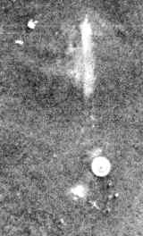
Below: Detail from shot above showing the Beacon and the triangulation station.